RotationVariable
require(["esri/renderers/visualVariables/RotationVariable"], function(RotationVariable) { /* code goes here */ });esri/renderers/visualVariables/RotationVariableThe rotation visual variable defines how features rendered with marker symbols or text symbols in a MapView are rotated. The rotation value is determined by mapping the values to data in a field, or by other arithmetic means with an Arcade expression.
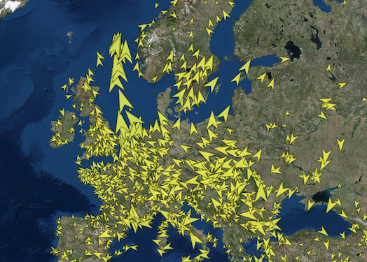
This object may be used to depict variables such as wind direction, vehicle heading, etc.
Known Limitations
In a SceneView rotation visual variables are not currently supported with marker symbols, text symbols, 3D icon symbol layers and 3D text symbol layers.
const rotationVisualVariable = {
  type: "rotation",
  field: "heading",
  rotationType: "geographic"
};
renderer.visualVariables = [ rotationVisualVariable ];
Constructors
- new RotationVariable(properties)
- Parameter:properties Objectoptional
See the properties for a list of all the properties that may be passed into the constructor.
Property Overview
| Name | Type | Summary | Class | |
|---|---|---|---|---|
| String | Only applicable when working in a SceneView. more details | more details | RotationVariable | |
| String | The name of the class. more details | more details | Accessor | |
| String | The name of the numeric attribute field that contains the data values used to determine the color/opacity/size/rotation of each feature. more details | more details | VisualVariable | |
| String|Number | The index of the visual variable in relation to its position in the visualVariables property of the renderer. more details | more details | VisualVariable | |
| Object | An object providing options for displaying the visual variable in the Legend. more details | more details | VisualVariable | |
| String | Defines the origin and direction of rotation depending on how the angle of rotation was measured. more details | more details | RotationVariable | |
| String | The visual variable type. more details | more details | RotationVariable | |
| String | An Arcade expression evaluating to a number. more details | more details | VisualVariable | |
| String | The title identifying and describing the associated Arcade expression as defined in the valueExpression property. more details | more details | VisualVariable |
Property Details
- axisString
Only applicable when working in a SceneView. Defines the axis the rotation visual variable should be applied to when rendering features with an ObjectSymbol3DLayer.
If the symbol resource is aligned such that its forward facing side points in the direction of the y-axis (the y-axis always points North in WGS84 or WebMercator coordinates), its upwards facing side is pointing in the direction of the z-axis, and its right-hand side points in the direction of the x-axis (the x-axis always points East in WGS84 or WebMercator coordinates), then the following rotation axis will rotate the symbol as indicated by their name.
Possible Value Description heading The rotation of the symbol in the horizontal plane (i.e., around the z axis). tilt The rotation of the symbol in the longitudinal vertical plane (i.e., around the x axis). roll The rotation of the symbol in the lateral vertical plane (i.e., around the y axis). - Default Value:heading
The name of the class. The declared class name is formatted as
esri.folder.className.
The name of the numeric attribute field that contains the data values used to determine the color/opacity/size/rotation of each feature.
The index of the visual variable in relation to its position in the visualVariables property of the renderer.
An object providing options for displaying the visual variable in the Legend.
- Properties:
- optionalshowLegend Boolean
Indicates whether to show the visual variable in the legend.
optionaltitle StringThe title describing the visualization of the visual variable in the Legend. This takes precedence over a field alias or valueExpressionTitle.
- rotationTypeString
Defines the origin and direction of rotation depending on how the angle of rotation was measured. See the table below for a list of possible values. This property only applies to rotations around the
headingaxis.Value Description geographic Rotates the symbol from the north in a clockwise direction. arithmetic Rotates the symbol from the east in a counter-clockwise direction. - Default Value:geographic
- typeStringreadonly
The visual variable type. For RotationVariable, this value is always
rotation.
An Arcade expression evaluating to a number. This expression can reference field values using the
$featureglobal variable and perform mathematical calculations and logical evaluations at runtime. The values returned from this expression are the data used to drive the visualization. This takes precedence over field. Therefore, this property is typically used as an alternative to field in visual variables.- See also:
The title identifying and describing the associated Arcade expression as defined in the valueExpression property. This is displayed as the title of the corresponding visual variable in the Legend in the absence of a provided
titlein the legendOptions property.
Method Overview
| Name | Return Type | Summary | Class | |
|---|---|---|---|---|
| RotationVariable | Creates a deep clone of the RotationVariable. more details | more details | RotationVariable | |
| * | Creates a new instance of this class and initializes it with values from a JSON object generated from a product in the ArcGIS platform. more details | more details | RotationVariable | |
| Object | Converts an instance of this class to its ArcGIS portal JSON representation. more details | more details | RotationVariable |
Method Details
- clone(){RotationVariable}
Creates a deep clone of the RotationVariable.
Returns:Type Description RotationVariable A deep clone of the rotation visual variable that invoked this method. Example:// Creates a deep clone of the visual variable var renderer = renderer.visualVariables[0].clone();
- fromJSON(json){*}static
Creates a new instance of this class and initializes it with values from a JSON object generated from a product in the ArcGIS platform. The object passed into the input
jsonparameter often comes from a response to a query operation in the REST API or a toJSON() method from another ArcGIS product. See the Using fromJSON() topic in the Guide for details and examples of when and how to use this function.Parameter:json ObjectA JSON representation of the instance in the ArcGIS format. See the ArcGIS REST API documentation for examples of the structure of various input JSON objects.
Returns:Type Description * Returns a new instance of this class.
- toJSON(){Object}
Converts an instance of this class to its ArcGIS portal JSON representation. See the Using fromJSON() topic in the Guide for more information.
Returns:Type Description Object The ArcGIS portal JSON representation of an instance of this class.