DimensionalDefinition
require(["esri/layers/support/DimensionalDefinition"], function(DimensionalDefinition) { /* code goes here */ });esri/layers/support/DimensionalDefinitionA dimensional definition defines a filter based on one variable and one dimension. You can filter with one or multiple dimensional slices. Instances of this class are typically used when filtering data based on slices or ranges in one or more dimensions with MosaicRule.
For example, a single ImageryLayer may have a depth dimension storing sea temperatures for the same pixel location at various depths. Another dimension could be time, where the same pixel stores multiple values based on a window of time.
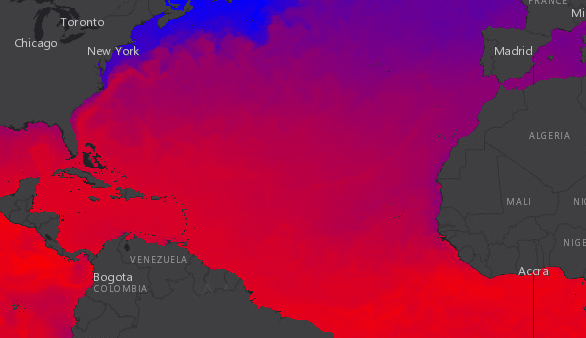
The sample in the image below renders sea temperature at the surface for a specific time in the year.
var multidimensionalDefinition = [];
multidimensionalDefinition.push(new DimensionalDefinition({
  variableName: "water_temp",
  dimensionName: "StdZ", // water depth
  values: [0], // sea surface or 0ft
  isSlice: true
}));

var mosaicRule = new MosaicRule();
mosaicRule.multidimensionalDefinition = multidimensionalDefinition;
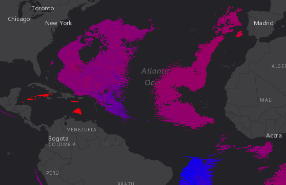
In contrast, the following image renders sea temperature data from the same service at 5000 meters below the surface within the same time window.
var multidimensionalDefinition = [];
multidimensionalDefinition.push(new DimensionalDefinition({
  variableName: "water_temp",
  dimensionName: "StdZ", // water depth
  values: [-5000], // 5000 m below
  isSlice: true
}));

var mosaicRule = new MosaicRule();
mosaicRule.multidimensionalDefinition = multidimensionalDefinition;
See the hasMultidimensions property of the ImageryLayer to check if the layer stores data for one or more variables in multiple dimensions. If it does, then the multidimensionalInfo property of the layer will contain the dimension names and values that may be used in the filters.
// display the pixels containing salinity values between -10 and 10
var definition = new DimensionalDefinition({
  variableName: "Salinity",
  dimensionName: "StdZ",
  values: [-10,10],
  isSlice: false
});
Constructors
- new DimensionalDefinition(properties)
- Parameter:properties Objectoptional
See the properties for a list of all the properties that may be passed into the constructor.
Property Overview
| Name | Type | Summary | Class | |
|---|---|---|---|---|
| String | The name of the class. more details | more details | Accessor | |
| String | The dimension associated with the variable. more details | more details | DimensionalDefinition | |
| Boolean | Indicates whether the values indicate slices (rather than ranges). more details | more details | DimensionalDefinition | |
| Object[] | An array of tuples [min, max] each defining a range of valid values along the specified dimension. more details | more details | DimensionalDefinition | |
| String | The required variable name by which to filter. more details | more details | DimensionalDefinition |
Property Details
- Since: ArcGIS API for JavaScript 4.7
The name of the class. The declared class name is formatted as
esri.folder.className.
- dimensionNameString
The dimension associated with the variable.
- isSliceBoolean
Indicates whether the values indicate slices (rather than ranges).
- Default Value:false
- valuesObject[]
An array of tuples [min, max] each defining a range of valid values along the specified dimension.
Example:// -10 is the minimum valid value and 10 is the maximum valid value definition.values = [-10,10];
- variableNameString
The required variable name by which to filter.
Method Overview
| Name | Return Type | Summary | Class | |
|---|---|---|---|---|
| DimensionalDefinition | Creates a clone of the DimensionalDefinition object. more details | more details | DimensionalDefinition | |
| * | Creates a new instance of this class and initializes it with values from a JSON object generated from a product in the ArcGIS platform. more details | more details | DimensionalDefinition | |
| Object | Converts an instance of this class to its ArcGIS portal JSON representation. more details | more details | DimensionalDefinition |
Method Details
- clone(){DimensionalDefinition}
Creates a clone of the DimensionalDefinition object.
Returns:Type Description DimensionalDefinition A clone of the object that invoked this method. Example:// Creates a clone of the DimensionalDefinition var dimensionalDefinition1 = dimensionalDefinition.clone();
- fromJSON(json){*}static
Creates a new instance of this class and initializes it with values from a JSON object generated from a product in the ArcGIS platform. The object passed into the input
jsonparameter often comes from a response to a query operation in the REST API or a toJSON() method from another ArcGIS product. See the Using fromJSON() topic in the Guide for details and examples of when and how to use this function.Parameter:json ObjectA JSON representation of the instance in the ArcGIS format. See the ArcGIS REST API documentation for examples of the structure of various input JSON objects.
Returns:Type Description * Returns a new instance of this class.
- toJSON(){Object}
Converts an instance of this class to its ArcGIS portal JSON representation. See the Using fromJSON() topic in the Guide for more information.
Returns:Type Description Object The ArcGIS portal JSON representation of an instance of this class.